3D visual information and GIS technologies for paintings’ documentation in the M Sepulchre in the Vatican Necropolis |
 |
|||
The M Sepulchre GIS
|
GIS and visual
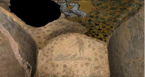
information The main goal of our project was the virtual detailed 3D reconstruction of micro-models of paintings documentation by digital techniques and through different information layers, in order to have a final "cognitive" representation. In the case of a monument, such as a tomb, the best cognitive micro-representation is increasing the level of knowledge and of interpretation, practically de-constructing, in a first phase the pictorial and architectonic information, finally, recombining every component of the structure into a unique, whole virtual model. The process of de-construction and re-construction is a cognitive dynamic process of knowledge that we think is fundamental for a new approach to the digital graphic representation: we disassemble and then reassemble information. Thus a model becomes an articulated set of multilayered information, where the whole increased model is more significant than each single component. In this context, 3D GIS (Geographic Information System) and virtual reality technologies have been fundamental in obtaining good results. In fact, even though GIS software is typically used in territorial studies and analyses, it can give very interesting results also in other non-traditional contexts. Furthermore we have to consider GIS as an open planning platform, where the scientific user chooses the directions of research, combining the several layers of documentation. Now, click on the walls for displaying the movies
All the phases of work have been carried out exchanging all the data on line (by Internet tools) and creating a network of persons with different roles and functions: topographic survey and acquisition (A. Bizzarro, S. Tilia), data processing (S. Tilia), rectification and topological referencing of the images (A. Tilia), GIS implementation and 3D processing (M. Forte), VRML reconstructions and virtual reality applications (A. Tilia, S. Tilia, M. Forte). In order to process the digital data the following software have been used:
In our case the most important phase of the work was the superimposition of the data, that is the representation of the data in a unique referenced co-ordinate system, through the exact use of a GIS implementation. |
The working project
|
||